What Are Topographic Surveys and Why Are They Essential?
Topographic surveys are a set of techniques used to collect accurate information about land: its shape, boundaries, level differences, and relationship to the surrounding area. All this data is then converted into a topographic plan, which is a graphical representation of the site using coordinates and technical drawings.
In practice, the surveyor “translates” the physical reality of the site into clear plans that can be used by designers, authorities, and contractors. Without these plans, design and permitting become almost impossible.
Topographic surveys tell you clearly:
- where the exact property boundaries are;
- what elevation differences exist on the land;
- how the site relates to roads and neighboring properties;
- where foundations, utilities, and buildings can be correctly placed.
Why Topographic Surveys Matter for Safety, Legality, and Costs
Imagine installing your fence “by eye,” without clearly knowing where your property ends. During land registration, you discover that you extended 40 cm onto your neighbor’s land. The result? Lost time, additional costs, and often legal disputes.
When topographic surveys are missing or inaccurate, problems appear from three directions:
- Additional costs – placement errors can lead to demolition, utility relocation, or expensive design changes.
- Legality – without approved cadastral documentation and topographic plans, you cannot obtain a building permit.
- Safety – a building placed on uneven ground, weak soil, or in the wrong position may later develop structural issues.
Types of Topographic Surveys You May Need
Topographic surveys for building permits
Romanian law requires landowners to submit a topographic survey in order to obtain a building permit. Authorities review these plans, analyze the actual site conditions, and approve the project only if urban planning rules are respected.
Site setting out for foundations and utilities
Once you receive the permit, the next step is site setting out. The surveyor marks the exact locations of the house, foundations, and utility routes for water, gas, or electricity. This helps the contractor know precisely where to excavate and where to place pipelines, without the risk of intersecting other networks.
Topographic plans approved by OCPI
OCPI (Land Registry and Real Estate Publicity Office) and ANCPI at national level verify and validate topographic plans. These documents are mandatory for cadastral documentation and for land registration in the Land Book. If you bought agricultural land that you want to convert into buildable land, you will need topographic plans approved by OCPI.
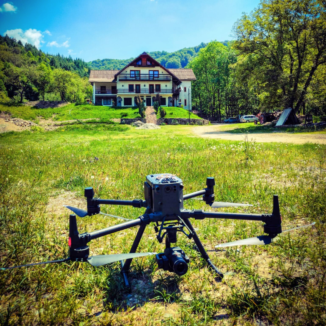
High-precision GPS surveys
In industrial projects or logistics halls, perfect alignment of columns and steel structures is required. This is where high-precision GPS surveys come in, with centimeter-level accuracy, even on very large surfaces. These are essential for industrial and infrastructure projects.
Advanced topographic surveys for construction and infrastructure
For complex projects, the Dromcons team performs advanced topographic surveys, adapted to each type of construction. Our construction topography services include:
- Site plan (PAC) – a document reflecting the real site conditions, necessary during design and approval stages.
- Volume calculations – determining exactly how much soil must be excavated or brought in.
- PUG – PUZ – PUD support – complete assistance for urban planning documentation, essential in large real estate developments.
- Setting out – marking the project accurately on site, so construction matches the design.
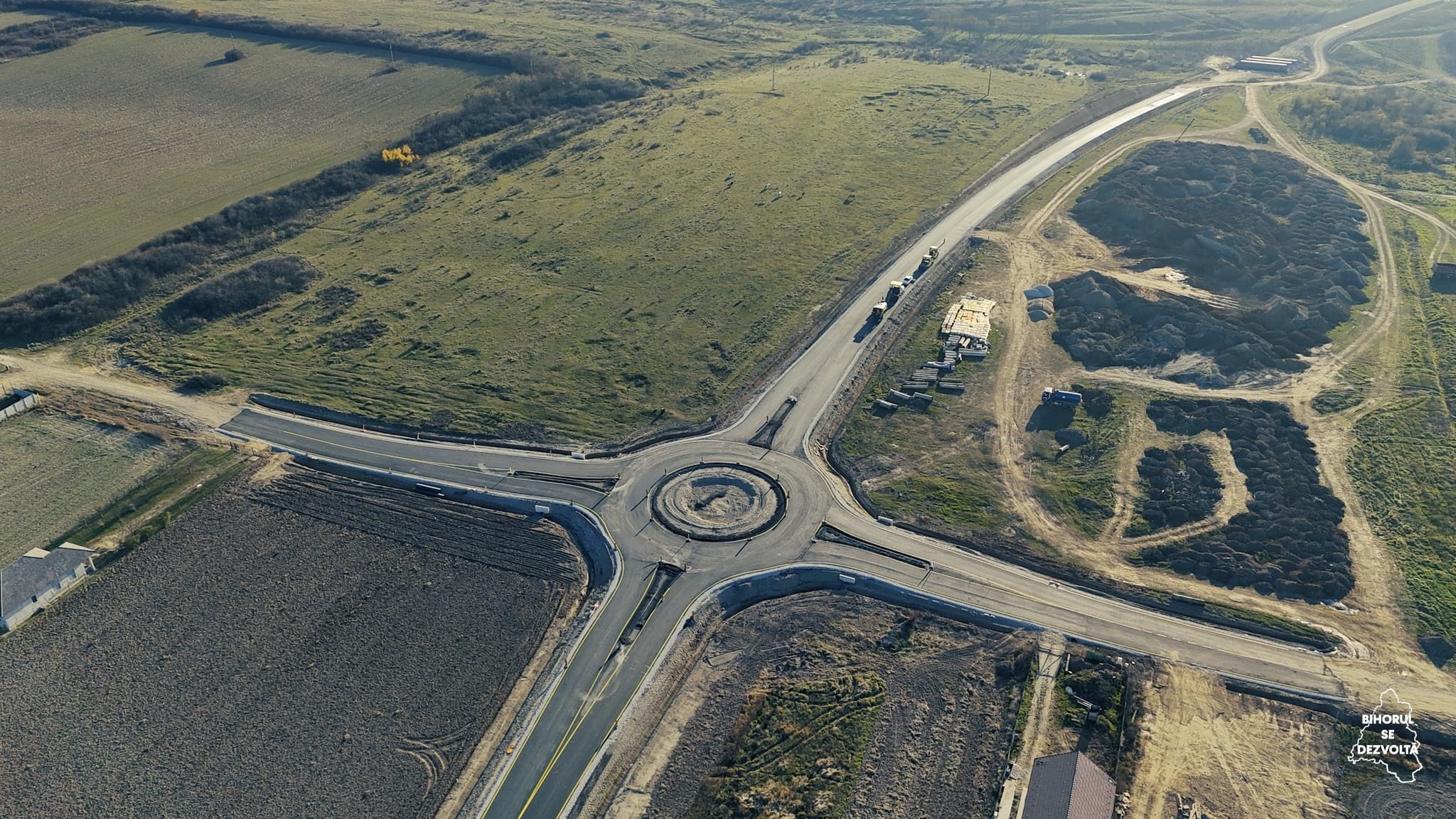
- Orthophotos – geometrically corrected aerial images, ideal for roads, residential neighborhoods, and industrial areas.
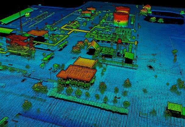
- 3D scanning – the use of modern technologies for complex structures and terrain.
- Lidar surveys – extremely detailed digital models, used in large-scale infrastructure projects.
How Does the Process Work from Site to Final Plan?
From the client’s perspective, the topographic process may seem complicated. In reality, it is a well-structured workflow through which Dromcons transforms a physical site into clear plans, ready to be used for design and permitting.
- Document review – we check the ownership documents, existing plans, and project requirements. This ensures that the measurements are made correctly, based on the real site boundaries.
- Field survey – the team goes on site with total stations, high-precision GPS equipment, and, where needed, drones. Essential points, level differences, and neighboring elements are measured.
- Data processing – the information is entered into specialized software, resulting in a detailed digital plan containing all the elements needed by designers.
- Documentation delivery – the client receives the plans and documents required by authorities and the construction team.

Benefits of Topographic Surveys for Landowners and Companies
For both private landowners and companies, construction safety is the main advantage of properly executed topographic surveys. Beyond safety, there are several other important benefits.
Benefits for private owners
If you want to build a house with a basement, a topographic survey shows the level differences, groundwater risk, and the ideal location of the building. As a result:
- you avoid unexpected expenses caused by additional works;
- you gain legal clarity – no disputes with neighbors or delays with authorities;
- you can make informed decisions regarding foundation type and technical solutions.
Benefits for companies and developers
For a 10 km road or an industrial platform, a few setting-out errors can mean utility relocations, delays of several months, and extra costs worth millions. That is why companies need high-precision topography:
- accuracy – designers and contractors work based on exact coordinates;
- speed – the site is not blocked by later corrections;
- cost reduction – relocations, partial demolitions, and redesign are avoided.
Practical Examples from the Dromcons Portfolio
1. Arad East Bypass
For this major road infrastructure project, Dromcons delivered: approximately 11 km of road, 7 intersections, and numerous auxiliary works. Our team provided detailed topographic studies, permits and approvals, as well as a complex geotechnical study with 75 boreholes. Without accurate measurements, the road route and intersections could not have been designed correctly.
2. Oradea Metropolitan Ring Road
This project involved the construction of an 8 km road and 3 intersections, in partnership with local authorities. It included 51 boreholes and detailed topographic studies to ensure road stability and compliance with urban planning rules. The result: safe and durable infrastructure delivered without delays.
You can explore more projects in the Dromcons portfolio gallery, where you will find works in topography, roads and bridges, geotechnical studies, and execution.
Why Choose Dromcons for Topographic Surveys?
- More than 20 years of experience – public and private projects, all delivered safely and on time.
- Modern equipment and an in-house laboratory – we ensure maximum precision and fast results, without relying on external laboratories.
- Fast response in western Romania and nationwide coverage, for projects of any size.
- Integrated services – from topographic surveys and cadastral documentation, to geotechnical studies, design, and execution. You work with one partner from start to finish.
If you are also interested in the design stage, read more about our civil construction design services .
Conclusions: A Safe Project Starts with Accurate Topographic Surveys
Without properly executed topographic surveys, any construction project — from a house to a motorway — risks being blocked by errors, delays, and unexpected costs. With Dromcons, the land is analyzed in detail, and your project starts from a solid and reliable foundation.
Do you own land or plan to build? Contact the Dromcons team for fast, accurate, and approved topographic surveys, adapted to your project.
Contact Us for a Topographic Survey Offer